314 Boden Avenue
Carnegie, PA 15106
© COPYRIGHT RPG RESOURCES, 2023 TERMS OF USE PRIVACY POLICY

We are committed to guiding client’s projects toward success in a safe, efficient and environmentally responsible manner. At the core of RPG, we believe in a set of values that drive our staff and each project we complete:
![]() Safety
Safety
Keep Personnel out of hazardous site locations
![]() Automation
Automation
Automated repeated data collection
![]() Cost
Cost
Collect vastly more information in a shorter period of time
![]()
Actionable Data
Gain insight to make real time decisions
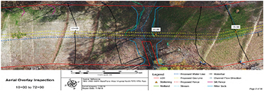
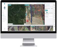
As-Built Conformance
High resolution aerial imagery overlaid with provided blueprints.
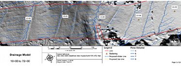
Drainage Model
Drainage algorithm predicts water flow using 3D surfacing scanning data.
Slope Threat Model
Identify slip prone areas by highlighting slopes based on gradient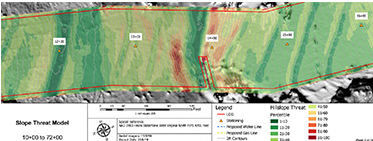 .
.
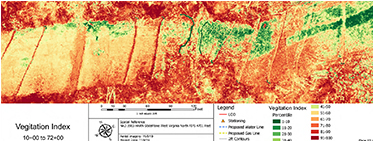
Vegetation Analysis
Near-inferred light is used to detect leaf chlorophyll levels, calculate health, and determine growth percentages.
High Resolution Imagery
5.2K resolution cameras equipped with magnifying lenses give powerful insight to engineers, inspectors, and project managers. RPG partners with innovative data management companies to deliver, store, and share inspection imagery. Decreasing man hours on and off site, while giving clients online access to customizable reports.
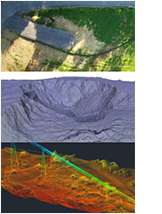
Orthomosaic
Essentially a high resolution satellite image. It’s georeferenced, spatially accurate, and current.
DEM
Digital elevation models are TIN surfaces generated from our 3D Point Clouds.
3D Point Cloud
LAS. Point Cloud files consist of millions of individual data points on an XYZ axis.
314 Boden Avenue
Carnegie, PA 15106
© COPYRIGHT RPG RESOURCES, 2023 TERMS OF USE PRIVACY POLICY